


Procedural Generation
Generates arbitrary road networks of any size defined by the raw boundary points of various lanes.
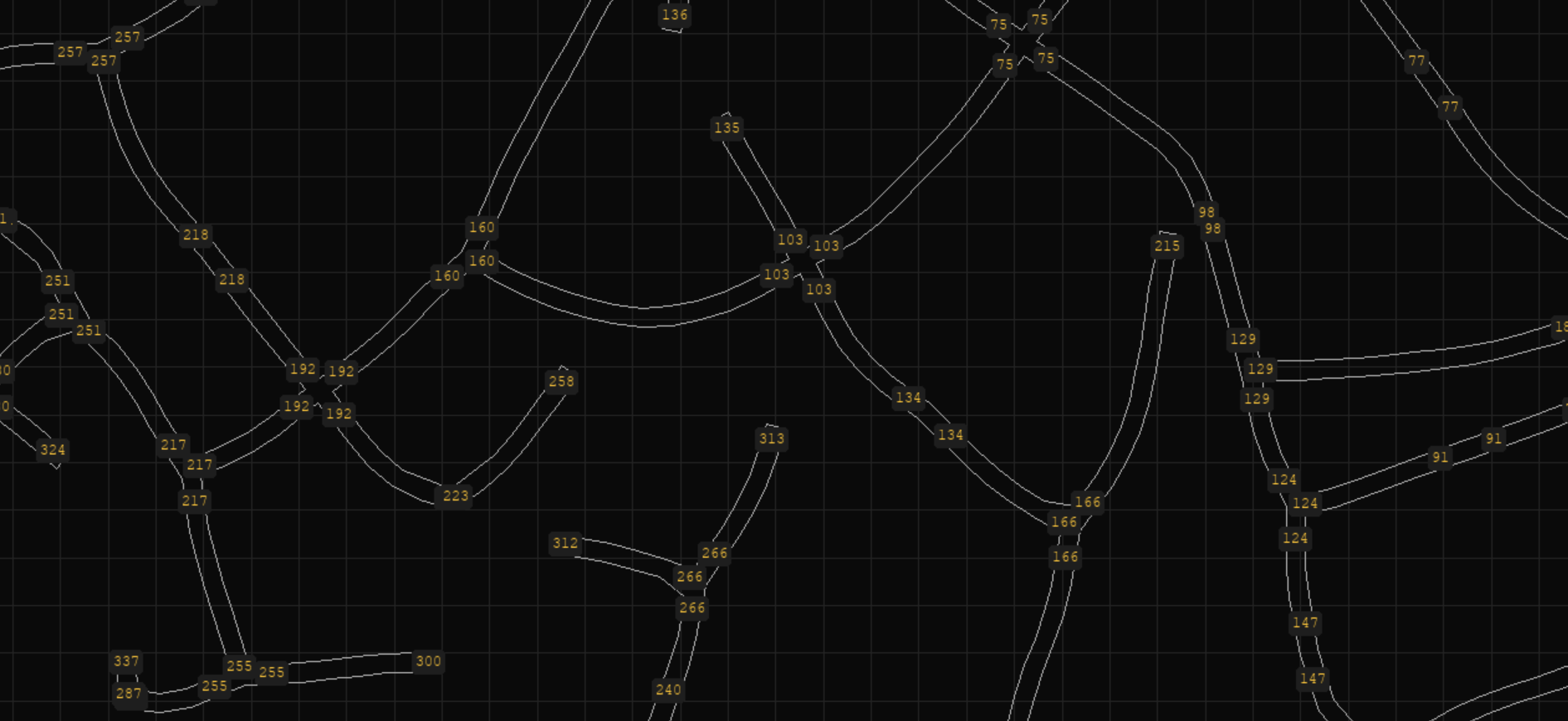
Use
import numpy as np

from highway_env.road.generation.generator import (
    generate_random_lanes, default_params
)
from highway_env.road.lane import PolyLane
from highway_env.road.partitioned_road import PartitionedRoadNetwork
from highway_env.road.road import LineType, Road

generation_params = default_params()
lanes = generate_random_lanes(rng = np.random.default_rng(), provided_params = generation_params)

## inside env._make_road():

# We now have a list of Lane that contains the raw geometrical boundary points
# of our road network + the nodes each lane connects to.
# We must now construct our RoadNetwork from this
net = PartitionedRoadNetwork(partition_gridsize=30)
for lane in lanes:
    real_lane = PolyLane(
        lane_points=lane.points,
        left_boundary_points=lane.left_points,
        right_boundary_points=lane.right_points,
        line_types=(LineType.CONTINUOUS, LineType.CONTINUOUS),
    )
    net.add_lane_bidirectional(lane.start, lane.end, real_lane)

self.road = Road(net)
The Generation Process
The generation process occurs in 5 distinct phases:
Random Swarm Generation
Rectification
Twist Optimization
Boundary Creation
Validation
Phase 1: Random Swarm Generation
A single ‘agent’ starts at the origin
This agent moves forward and randomly turns left/right
The path the agent takes broadly dictates the positioning of a lane
An agent may spontaneously reproduce, which creates a fork with multiple new agents to be created. Agents will die if they ram into another lane
Phase 2: Rectification
Lanes that consist of less than 3 points are destroyed
Endpoints that ram into other lanes must make a junction with the other lane. This means dividing the rammed lane into two halves at the new junction point
Neighboring endpoints that form a common junction must be made to have the same string location identifier
Looping lanes whose start and end location are the same are considered useless and are removed
Phase 3: Twist Optimization
The endpoints of multiple lanes at an intersection must properly point into each other. To ensure this happens, we twist the endpoints into an optimal configuration via gradient-descent. To twist means to make each line segment of a lane a ‘servo actuator’ that is attached to the preceding line segment, and then rotating them a fixed amount in unison
If the lane is too short to be twisted, we rotate the whole lane
Endpoints are also trimmed and squished to ensure they don’t overshoot the intersection point of other endpoints in the junction
Additionally, where there are two lanes that have the same start + end location and trace a similar path after twisting, one is removed
Phase 4: Boundary Creation
Borders are defined by a left and right sequence of points
At junctions, these borders are made to intersect at common points properly with the borders of other lanes
Dead-ends (junctions with only one endpoint) are sealed off as well by letting the right boundary point extend over to the left side
Phase 5: Validation
Mistakes in the generation process, although rare, can still occur, such as lanes that jutt into other lanes, overly narrow intersection bottlenecks, or even disjoint, unreachable clusters of road network
To combat this, every lane is checked for its traversibility. This is done by simulating small physics-based balls that are drawn to the end of the lane and are repelled by its borders. If no ball reaches the end of the lane, the lane is considered blocked. All blocked lanes are then removed from the network
The network is also checked for any separate, disjoint clusters. If there are multiple such unreachable clusters, only the largest one is retained and the rest are deleted entirely
Parameters Guide
target_num_endpoints: determines the size of the road network
forward_speed: step speed of an agent; determines how long each individual lane segment is
age_of_maturity: timesteps before an agent can replicate or die; provides a hard limit on the interval between two consecutive forks.
lane_width: lateral width of all lanes.
perlin_variation_params - Certain parameters are allowed to be continually varied across space so as to create differing regions or ‘biomes’ with differing road properties. For each of these parameters, a lower and upper bound on their value is specified. Here are these such parameters:
jitteriness - erraticity of how agents turn left/right (lower value = smoother paths)
max_turn_speed - maximum angular velocity of an agent (lower = straighter roads)
replication_chance - the tendency of forks in the road to occur (higher = denser road networks). A value of 0 will cause a generation fault. A very low value (on the order of 0.01) may also cause generation faults if the max_turn_speed is not also low (< 1.0).
spontaneous_death_chance - the tendency of spontaneous dead-ends to occur.
In addition to generation parameters, a seeded random number generator must be provided as well.
Spatial Hashing
Grid partitioning is used to reduce the computational cost of running proximity checks on large numbers of lanes.
It is used throughout the generation process and is also used outside of it (specifically in LaneLidarObservation, PartitionedRoadNetwork, and RandomRoadEnv)
A set of functions that support grid partitioning is available under generation/spatial_hash.py
Visualizer
scripts/generation_visualizer.py allows each intermediate step of the generation process to be seen directly for debugging/understanding purposes.